Difference between revisions of "EUROKITE PROJECT DATASHARING"
| (13 intermediate revisions by the same user not shown) | |||
| Line 2: | Line 2: | ||
{{DISPLAYTITLE: Project datasharing using Anitra (guide for Eurokite data controllers)}} | {{DISPLAYTITLE: Project datasharing using Anitra (guide for Eurokite data controllers)}} | ||
| − | + | ===Overview to „Groups and Projects“ and to Eurokite data categorisation terminology=== | |
: Eurokite Data Use Agreements (DUA) signed between project partners are implemented using Anitra Groups/Project functionality. | : Eurokite Data Use Agreements (DUA) signed between project partners are implemented using Anitra Groups/Project functionality. | ||
| − | : According to DUAs, the Tracking (Telemetry) data are classified in to A, B, and C categories. | + | :According to DUAs, the Tracking (Telemetry) data are classified in to A, B, and C categories. |
| − | : A = project data made available top-down from MEGEG to Partners filtered by the geography access specified in DUA. | + | ::A = project data made available top-down from MEGEG to Partners filtered by the geography access specified in DUA. |
| − | : B = data where certain partner directly participated e.g. during the tagging are available for the involved partner in an unfiltered way | + | ::B = data where certain partner directly participated e.g. during the tagging are available for the involved partner in an unfiltered way |
| − | : C = data made available bottom-up i.e. from Associated Beneficiary to the project. If not specified otherwise the data are visible to other project partners again based on the geography access | + | ::C = data made available bottom-up i.e. from Associated Beneficiary to the project. If not specified otherwise the data are visible to other project partners again based on the geography access |
| − | : Overview of the Eurokite tracking data structure by ABC categories is available in „Project“ functionality („Tracking/Animals“ tab) | + | :Overview of the Eurokite tracking data structure by ABC categories is available in „Project“ functionality („Tracking/Animals“ tab) |
| + | :[[File:01_overview_project_structure.jpg|605px]] | ||
| + | |||
| + | ===Overview to „Groups and Projects“ and to Eurokite data categorisation terminology=== | ||
| + | |||
| + | '''2) Workgroups/subprojects'''<br> | ||
| + | : For every project partner, a dedicated Eurokite workgroup/subproject is created to host partner-specific configurations such as persons involved, access and responsibility areas, trackings/animals shared to project, and similar (overview of all the groups can be seen in Eurokite project „Workgroups“ tab). | ||
| + | |||
| + | :[[File:02_workgroups.jpg|546px]] | ||
| + | : Click through in order to review and check the configuration and data of your workgroup | ||
| + | :[[File:02b_workgroup_detail.jpg|582px]] | ||
| + | '''3) Data controllers'''<br> | ||
| + | |||
| + | : Each project partner designates one person as a „data controller“ (DC) and the DC then manages data access for other people. <br> | ||
| + | : E.g Fabienne being DC for the LPO workgroup can propose the list of French names using „+ Add person“ button assigning them the „Subproject/workgroup access“ role.<br> | ||
| + | :[[File:03_datacontroller_adding_people.jpg|626px]] | ||
| + | : Once proposed the name is displayed to Eurokite project admins and confirmed by them. All the aproved person receive data access for all the „top-down“ data (categories ABC) | ||
| + | |||
| + | '''4) Geographic Access'''<br> | ||
| + | : You can review the list of Trackings/Animals available for your organisation in Trackings/Animals tab of your workgroup profile. Besides Trackings/Animals of A+B categories (which are available unfiltered), a dynamicaly updated category „Shared based on geography access“ is displayed. Any animals migrating through or staying within the area matching organisation`s „geography access“ area are dynamicaly shared and visible to the persons with approved access.<br><br> | ||
| + | : e.g. „Geographic access“ for LPO is set to France | ||
| + | :[[File:04_geographic_access.jpg|619px]] | ||
| + | : >> therefore all the birds crossing French territory are visible to the French team: | ||
| + | :[[File:04b_geographic_access_france.jpg|605px]] | ||
| + | |||
| + | '''5) Available Data '''<br> | ||
| + | : The share makes all the tracking data (data points and full tracks) and metadata (e.g. origin data) related to particular Tracking/Animal visible in Anitra maps, profiles, timelines, tables, and graphs. Also, all the derived data calculated from the tracking data (such as mortality warnings or night roost clusters) are available.<br><br> | ||
| + | : Note currently (temporarily) even all the data outside of the „access geography area“ are shared and visible. In relation to that, the export/download of the geographically shared data is temporarily disabled till the scheme is fully verified and approved and till improved geography filtering is implemented for the exporting functionality. | ||
| + | |||
| + | '''6) More structured hierarchy for your workgroups '''<br> | ||
| + | : In case you prefer to structure your team more in terms of geography (eg creating subteams limited to particular admin regions of your country) please contact us and to help you configure the structure. | ||
| + | |||
| + | '''7) Check the Anitra help pages for General Anitra usage info '''<br> | ||
| + | : The help is available under the „question mark“ icon in the left side navigation menu or in the right-click context dialog. | ||
| + | : The icon links to our Online user guide: https://anitracking.com/wiki | ||
| + | :[[File:05 help.jpg|605px]] | ||
Latest revision as of 20:03, 8 September 2022
Overview to „Groups and Projects“ and to Eurokite data categorisation terminology
- Eurokite Data Use Agreements (DUA) signed between project partners are implemented using Anitra Groups/Project functionality.
- According to DUAs, the Tracking (Telemetry) data are classified in to A, B, and C categories.
- A = project data made available top-down from MEGEG to Partners filtered by the geography access specified in DUA.
- B = data where certain partner directly participated e.g. during the tagging are available for the involved partner in an unfiltered way
- C = data made available bottom-up i.e. from Associated Beneficiary to the project. If not specified otherwise the data are visible to other project partners again based on the geography access
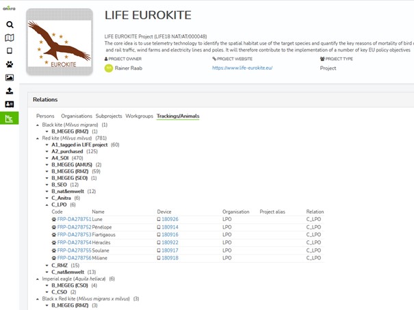
- Overview of the Eurokite tracking data structure by ABC categories is available in „Project“ functionality („Tracking/Animals“ tab)
Overview to „Groups and Projects“ and to Eurokite data categorisation terminology
2) Workgroups/subprojects
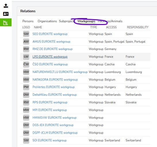
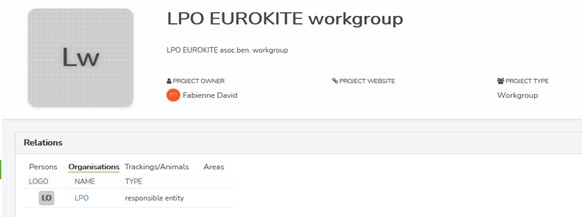
- For every project partner, a dedicated Eurokite workgroup/subproject is created to host partner-specific configurations such as persons involved, access and responsibility areas, trackings/animals shared to project, and similar (overview of all the groups can be seen in Eurokite project „Workgroups“ tab).
3) Data controllers
- Each project partner designates one person as a „data controller“ (DC) and the DC then manages data access for other people.
- E.g Fabienne being DC for the LPO workgroup can propose the list of French names using „+ Add person“ button assigning them the „Subproject/workgroup access“ role.
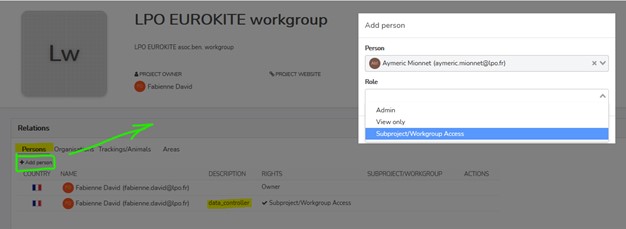
- Once proposed the name is displayed to Eurokite project admins and confirmed by them. All the aproved person receive data access for all the „top-down“ data (categories ABC)
4) Geographic Access
- You can review the list of Trackings/Animals available for your organisation in Trackings/Animals tab of your workgroup profile. Besides Trackings/Animals of A+B categories (which are available unfiltered), a dynamicaly updated category „Shared based on geography access“ is displayed. Any animals migrating through or staying within the area matching organisation`s „geography access“ area are dynamicaly shared and visible to the persons with approved access.
- e.g. „Geographic access“ for LPO is set to France
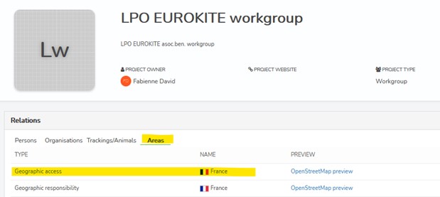
- >> therefore all the birds crossing French territory are visible to the French team:
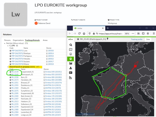
5) Available Data
- The share makes all the tracking data (data points and full tracks) and metadata (e.g. origin data) related to particular Tracking/Animal visible in Anitra maps, profiles, timelines, tables, and graphs. Also, all the derived data calculated from the tracking data (such as mortality warnings or night roost clusters) are available.
- Note currently (temporarily) even all the data outside of the „access geography area“ are shared and visible. In relation to that, the export/download of the geographically shared data is temporarily disabled till the scheme is fully verified and approved and till improved geography filtering is implemented for the exporting functionality.
6) More structured hierarchy for your workgroups
- In case you prefer to structure your team more in terms of geography (eg creating subteams limited to particular admin regions of your country) please contact us and to help you configure the structure.
7) Check the Anitra help pages for General Anitra usage info
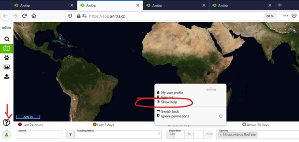
- The help is available under the „question mark“ icon in the left side navigation menu or in the right-click context dialog.
- The icon links to our Online user guide: https://anitracking.com/wiki
